|
|
Slope Stability/Subsidence /Karst Hazards
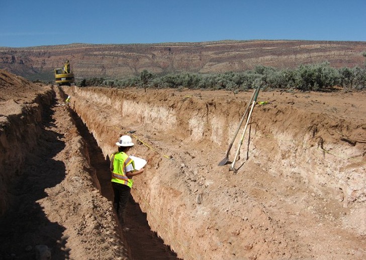
Exploration trenches deployed at the proposed
Pinion Mill site to evaluate the presence or absence of fissuring or collapse
related to the underlying Hermosa Formation, Montrose County, Colorado
|
Surface Fault Rapture Hazard and Karst Evaluation, Proposed Piñon Ridge
Uranium Mill Site, Montrose County, Colorado – Project Geologist 2008. As part of a general engineering geology evaluation for the
uranium mill site, the potential for Quaternary faulting and karst development
were identified on the 880-acre site.
The potential hazards were related to the salt-dome collapse structure
defining the Paradox Valley where the site was located. Seismic refraction lines identified bedrock
displacement at depth, and field observations identified karst activity near
the site. To evaluate whether the
displacements at depth projected to the surface and displaced Quaternary
deposits, nearly 3,000 feet of exploration trenches were excavated across the
areas of the site scheduled for improvements.
Stratigraphic units were delineated on the basis of soil units truncated
by calcium carbonate horizons, and trench walls were logged at a scale of
1-inch to 5-feet. The results of the
trenching indicated that Quaternary displacement did not appear to be present
in the areas trenched. To evaluate
karst, a GPS survey was conducted to document “circular feature” areas
identified on aerial photography on and in the vicinity of the site. A total of 35 circular feature” areas were
visited and documented, with none of these areas showing evidence karst
activity. |
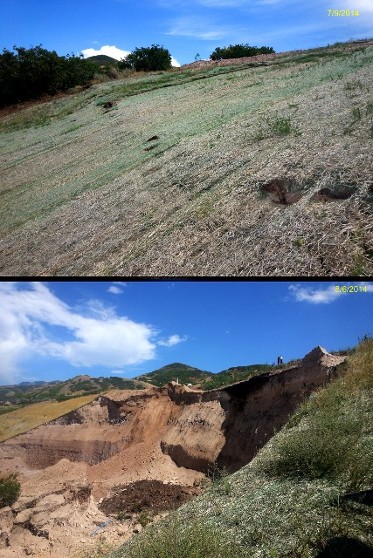
Engineering
Geology Support for Slope Stability Issues Eaglepointe Residential Subdivision;
North Salt Lake, Utah, Senior Geologist 2014. Reviewed and
reconnoitered on-going slope stability event at the Eaglepointe subdivision for
the geotechnical engineer. Un expected catastrophic
movement occurred August 5, 2014, during review period. Pre-failure observations indicated cracking
and distress of subject slopes, and inclinometer movements. Post failure
observations included mapping of landslide scale, observations of pre-failure
fill placements, and staffing geotechnical drilling operations. Opinions of conditions and events were provided
as a third-party source to the geotechnical engineer.
Pre-failure and post-failure images of the Eaglepointe slope, North Salt, Utah
|
|
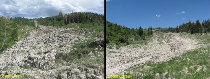
Landsliding on the South Fork and Cooley Creek Fork of the Twelvemile Creek drainage, Manti - LaSal National Forest, affects irrigation systems for the Gunnison-Mayfield irrigation districts, Sanpete County, Utah
|
Geological
Evaluation and Support for Geotechnical Planning and Economic Cost-Benefit
Analyses for Control of Sediment in Irrigation Water from Twelvemile Creek;
Sanpete County, Utah - Project Manager, 2008 through 2010. Water from the Twelvemile drainage has been
used for irrigation by farmers and ranchers surrounding the communities of
Mayfield and Gunnison, Utah since the mid 1800’s. Historical landslide movement
beginning in the 1980’s in Twelvemile drainage has resulted in excessive
suspended sediments that result in infrastructure damage and production losses
on the order a half-million dollars annually. Incumbent provided engineering
geology support and expertise for a multi-agency team tasked with developing a
feasible strategy for mitigating the losses from sediment. This on-going
project includes stakeholders from federal, state and county agencies. |
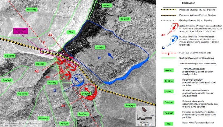
Landslide Hazards Questar ML 104 Gooseberry Creek Crossing, Sanpete County, Utah
|
Geological and
Geotechnical Responses to EIS Performance Standards for Proposed Natural Gas
Mainline, Questar Regulated Services - Gooseberry Creek Crossing; Sanpete
County, Utah - Project Geologist/Project Manager, 2001. Steep slopes surrounding the incised Gooseberry
Creek crossing were affected by past (inactive)and active landslide movement. Steep slope-landslide areas surrounding the crossing
area were mapped and reconnoitered in the field. Alternative routing for proposed ML 104 pipeline was recommended to
avoid existing landslide hazards. |
|
|
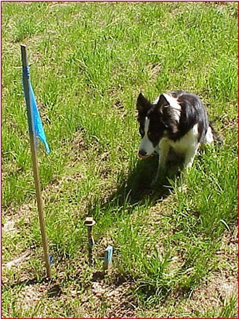
Geological and
Geotechnical Responses to EIS Performance Standards for Proposed Natural Gas
Mainline, Questar Regulated Services - Skyline Mine Crossing; Carbon and Emery
Counties, Utah - Project Geologist/Project Manager, 2001. Investigated an approximately two mile
section of right-of-way for the proposed ML 104 pipeline. Right-of-way section had been undermined by
longwall mining activity by Canyon Fuels LLC., between 1990 and 2000. Questar intended to route the proposed 24-inch
ML 104 pipeline across the undermined area.
Mining data and subsidence monitoring records were reviewed and future subsidence
movements were calculated. Best management
practices to accommodate for latent subsidence movement, and fractured foundation
strata were developed and recommended for pipeline construction.
Skip, survey monitor dog, Questar ML 41 Skyline Mine crossing, observing subsidence monitoring monument, Carbon County, Utah |
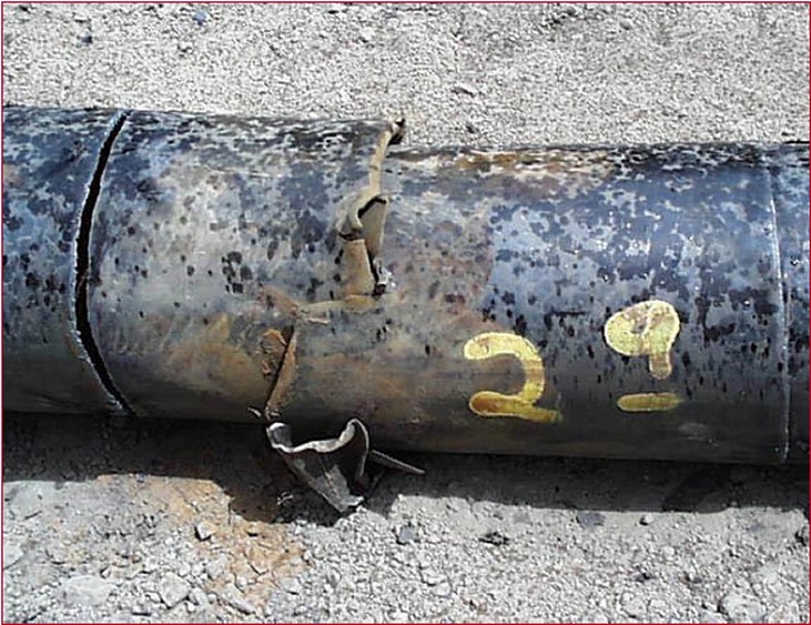
Distressed 18" x50 pipe recovered from abandoned Questar ML 41, Skyline Mine crossing, Carbon County, Utah |
The Cahaba
River, all 190 miles of it, is the longest remaining free-flowing river
in Alabama. Environmental opposition lead to the investigation Cahaba
River Trunk Sewer Tunnel in Jefferson County, Alabama |
Stability Assessment, Cahba
River Trunk Sewer Tunnel; Jefferson County, Alabama - Project Manager, 2002. A
professional team was retained to assess as third-party experts for the
geotechnical engineering and geologic hazards that could potentially impact the
12-foot diameter tunnel crossing beneath the Cahaba River near Birmingham
Alabama. As an independent entity the team examined the project from two
different time frames, namely the construction period and the operational
period. Based on an inspection of the site, inspection of existing tunnels in
the vicinity of the planned crossing, a review of the geotechnical samples, a
review of geological and mining information and records, a review of the plans
and specifications for the work, a review of the construction calculations and
construction plans, discussions with the engineers and constructors involved
with the projects, and a review of transcripts from public hearing and numerous
documents pertaining to this crossing the team concurred with the original
finding that this tunnel crossing could be safely built and safely operated
through its life cycle. |
|
|